/reboot/media/95268e66-9e53-11ed-b306-0242ac14000b/d246b0ac-74d3-11ef-a7b3-0242ac120010/1-1-capture-d-ecran-2024-09-17-105824.png)
How does Stereo2's GPS‑free stabilization work?
Stabilizing drones indoors or in confined spaces is a major challenge. Unlike outdoor environments, where GPS can provide precise data on a drone's position, confined environments do not allow the use of this type of technology. Multinnov, a leader in technological solutions for complex environments, has met this challenge by integrating visual odometry technology into its indoor drone, the Stereo2. This innovation enables the drone to maintain a stable, precise trajectory without the need for GPS.
In this article, we'll explore why the Stereo2 doesn't use GPS, the fundamentals of visual odometry, and how this technology redefines the possibilities for drones in confined environments.
Why doesn't the Stereo2 use GPS?
GPS is a widely used technology for navigation and stabilization of drones in outdoor environments. However, in indoor or confined environments, this technology quickly shows its limitations. GPS signals are either unavailable or too weak to provide reliable data. This makes the use of GPS ineffective, if not impossible, in contexts such as :
- Complex industrial environments: tunnels, warehouses, power plants, industrial chimneys.
- Underground areas: mining galleries, buried pipes.
- Confined or enclosed environments: tanks, vats, thick metal structures.
This is where visual odometry comes in. Unlike GPS, this technology relies on the analysis of the visual environment captured by on‑board cameras, enabling precise navigation and stabilization, even in the absence of external signals.
Visual odometry: a revolutionary alternative to GPS
What is visual odometry?
Visual odometry is an advanced technique that uses images captured by cameras to estimate the movement of an object in its environment. The process is similar to the way humans perceive movement by observing changes in their field of vision.
Here are the key stages in its operation:
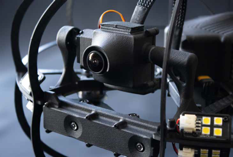
1. Image capture: Stereo2 is equipped with high‑definition cameras that continuously record the environment. These cameras play a central role in gathering the necessary visual data.
2. Feature detection: The system analyzes images to identify distinctive points in the environment, such as corners, patterns or specific textures. These points serve as references for motion tracking.
3. Displacement calculation: By comparing the positions of the characteristic points between several successive images, the algorithm determines the drone's movements in terms of translation and rotation.
4. Trajectory estimation: These data are integrated to calculate the drone's overall position and trajectory, enabling stable and precise navigation.
The benefits of visual odometry
Visual odometry offers several advantages that make it an ideal solution for drones like the Stereo2 in confined environments:
- Greater precision: By analyzing visual data in real time, this technology enables very fine stabilization, essential for high‑precision inspections or surveys.
- Independence from external signals: Unlike GPS, visual odometry is not dependent on satellite or radio signals. This makes it particularly suitable for areas where these signals are absent.
- Adaptability to different environments: Whether it's a complex metal structure or a space with little natural light, Stereo2's cameras and algorithms adapt to the specific conditions of each location.
- Enhanced safety: By guaranteeing stable navigation, visual odometry reduces the risk of collisions or incidents, particularly in sensitive or dangerous areas.

Integrating visual odometry into Stereo2
The Stereo2 is more than just a camera‑equipped drone; it's a real concentrate of advanced technologies, designed to meet the specific needs of inspections in confined environments.
Cutting‑edge technology for optimum stabilization
The Stereo2's high‑definition cameras, combined with sophisticated image processing algorithms, enable precise navigation, even in environments where visual cues are limited. What's more, the drone is able to compensate for sudden movements or disturbances, ensuring a smooth trajectory.
Application in confined environments
Thanks to visual odometry, the Stereo2 excels in contexts such as :
- Industrial inspections: checking the integrity of structures, detecting anomalies or collecting data in difficult‑to‑access environments.
- Preventive maintenance audits: provide detailed analyses to anticipate repair or replacement needs.
- Interventions in sensitive areas: navigate safely in hazardous environments, such as explosive atmospheres (ATEX zones).
A solution tailored to the needs of professionals
The Stereo2 is designed to meet the requirements of professionals working in complex environments. Its maneuverability, precision and independence from GPS signals make it an essential tool for those seeking both performance and safety.
Multinnov's Stereo2 is a perfect example of how technological innovation can transform limits into opportunities. By replacing GPS with visual odometry, this indoor drone pushes back the boundaries of confined‑area inspections. Thanks to high‑performance cameras and advanced algorithms, it offers stable, precise and safe navigation, even in the most complex environments.
For professionals operating in environments where precision and safety are crucial, the Stereo2 represents much more than a simple tool: it's a genuine technological revolution. By integrating this solution into their operations, companies can not only improve their efficiency, but also strengthen their competitiveness in the marketplace. To find out more about Stereo2 and its innovative capabilities, visit the Multinnov website.
:strip_exif()/reboot/media/95268e66-9e53-11ed-b306-0242ac14000b/7e1d7cf8-a2df-11ed-b843-0242ac14000b/1-1-multinnov-pour-fond-blanc.png)
:strip_exif()/reboot/media/95268e66-9e53-11ed-b306-0242ac14000b/7e1d7cf8-a2df-11ed-b843-0242ac14000b/1-1-multinnov-pour-fond-blanc.png)
/reboot/media/95268e66-9e53-11ed-b306-0242ac14000b/7aaa5026-bc09-11ed-9083-0242ac14000c/1-1-image4.jpg)
/reboot/media/95268e66-9e53-11ed-b306-0242ac14000b/62e2f1d0-d708-11ee-8f95-0242ac12000a/2-2-inspection-drone.jpg)
/reboot/media/95268e66-9e53-11ed-b306-0242ac14000b/0356b896-f35a-11ee-9e20-0242ac120013/2-2-inspection-drone.jpg)